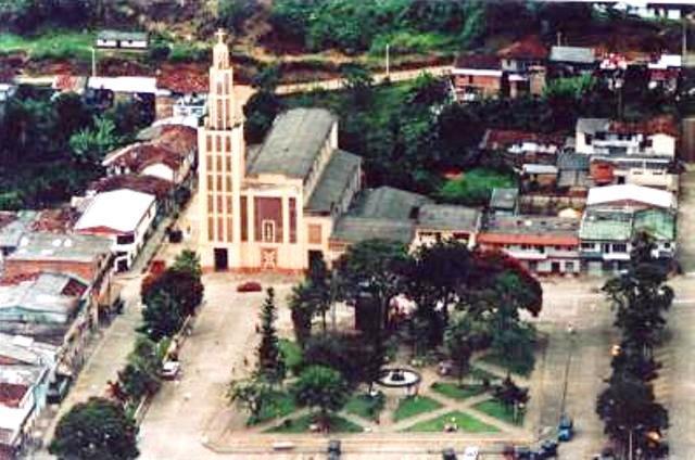
The Celia


La Celia, Risaralda, Colombia
Suggest Place to Visit
387
Track to location with GPS |
 |
Foundation closings: November 30, 1959
name of the founder (s): Martín Ortiz Romero / Manuel Marín / Balbina Osorio V. De Ortiz / Teodoro Loaiza / Laureano Loaiza / Carlos Echeverri / Manuel Tabares / Leonorcita Ortiz / Félix Gómez / Juan De Dios Holguín / Juan De La Rosa Jaramillo.
HISTORICAL REVIEW:
The territory where today it is located in the municipality of Celia, was inhabited in its beginnings by indigenous inhabitants of Cauca. Approximately from 1895 to 1902, the decanting wells that this nomadic region will have and will only cause the exploitation of some salt flats that were found there, in the place that today is known as the salt, bordering the part between the departments of Valle and Risaralda and the municipalities of La Celia and el Águila, respectively. Hunting and the approval of some plant species for sustenance were complementary activities that were carried out in the region without a colonizing contribution from these first settlers.
The river basin from 1903 to 1905 began to collect some inhabitants of Antioque towns who began to open forests and generate the first signs of agricultural production. Wood, corn, beans and native products were the main agricultural lines of the time. (The initial agricultural production did not include the cultivation of coffee, this was preceded by the cultivation of pastures for the exploitation of cattle, cane for the production of pots, bananas, cassava and vegetables).
The inhabitants of Antioquia, in the immediate middle of the territory, traveling bell, the horse, the Sanctuary and Apia, where they live and coexist with their families.
The first settlers arrived by the route of the municipality of Balboa, as in other sources of information. Balboa became more comfortable, in the same way, in the course of the horse, for agricultural trade and the supply of consumer goods that came from Manizales, Pereira and Cartago)
The basin of the year 1910 was found to be some very poorly closed buildings with a small construction that served as a roof and temporary shelter for settlers and workers.
In 1912 there were several poorly managed estates, including three large tracts of land that made up the three main estates of the region (El Salado, La Julia and La Celia), owned by the Antioquia and Caldense settlers. ; It was during this time that the department of Caldas was created (1905), which now belongs to the region that now occupies the municipality of La Celia.
Among the first colonizers, the names of Teodoro Luaiza, Laureano Loaiza stand out (it is important to highlight the writing of their surnames that some people relate to them as brothers and sisters and in the same family relationship); Mr. Félix Gómez, Manuel Tabares, Martín Orozco, Juan de la Rosa Jaramillo, Teodoro Hoyos, Daniel Zapata, Francisco Luís Zapata, Leonorcita Ortiz and a colonizer named Bermúdez, whose name and colonizing incidence are under investigation.
These first settlers gathered and woke up to dazzle and pack a piece of forest and guidua, in a flat place, on the banks of the Monos River, in order to build a central village so that they could establish their families and the families of the administrators in addition to serving as a meeting center, market, collection of products and starting and meeting point to send agricultural products to the business centers of Pereira, Cartago and Manizales and obtain these most important consumer products. to meet the basic needs of the settling wells that then inhabited the region.
In 1914 a large piece of land was cleared and 14 houses were built of guadua, wood from the region, a roof of mud and straw. This small house was known by the name of Barcelona, as well as by the name of Berlin, but due to the residents of the region, it was decided to put it in the name of one of the most popular and recognized properties, based on the settlers who built it on their own. base like La Celia, has new days.
Its territory is located at coordinates 4 59 north latitude and 76 2 west longitude, on the eastern slope of the Western Cordillera, its urban area at an approximate height of 1,559 meters and 67 km from the capital of the state of Rio Grande do Sul. It comprises 102Km2 which is equivalent to 2.54% of the total territory of the department.
It limits the North with the municipality of Santuario; by South with the municipality of Águila in the department of Valle; to the East with the Municipalities of Santuario and Balboa and to the West with the Departments of Chocó and Valle.
It corresponds to the western mountain range, it has the highest height over the Tatamá hill with 3950 meters and the Altos de Morrón, Molinos de viento and La Julia, most of its topography is broken representing more than 60%, undulating 35% and flat territory 5%. The urban area of the municipality is located on an alluvial ridge formed by the Monos River, surrounding the urban area in very steep slopes, the eastern slope of the town changes steep surfaces, with 100% greater slopes, which are in the eastern part of the same. 65% overpaid.
It is mainly formed by the Monos River, which has a length of 25km, and which crosses a large part of the urban area, flows into the Cañaveral River, which marks the limit with the department of Valle; the most important ruptures in the municipality are: Liboriana, La Cristalina, La Secreta, La Cascada, La Alejandría, La Manuela, La Sirena, El Clavel and El Tigre.
The main source of food in the municipality in general is the agricultural sector, mainly the cultivation of coffee in the field, through cleaning, waste, fertilization, collection of money, among others; in the second instance is the cultivation of the dominant hartón plant and the smallest proportion of other crops such as panelera cane and cold weather fruits. With the relationship in the urban area with the municipal administration, it is the one that generates the greatest demand for qualified and unskilled labor, followed by the education and health sectors and complemented by the informal economy with a variety of forms of employment.
Economic activities
The products that generate the greatest inputs for the agricultural sector in the municipality of coffee, Dominican hartón and sugar cane, minor crops such as corn, beans and vegetables, some fruit trees with cold weather such as the house in Castilla and Lulo, which are mainly used for family consumption and the sale of surpluses, which generates some incoming income; likewise, small-scale livestock activities such as sows, poultry, livestock and fish farming, which corresponds to a surplus equivalent to 40% of the total production of 1800 kg / year, being the main species exploited in Tila pía roja.
Currently, there is a support center that currently lacks the necessary funding for its normal operation. There are few commercial entities in the municipality, mainly due to the low volume of production and the impossibility of keeping the product on the market. The streets of the municipality that lead to the urban area are located in their great majority in a state and care, facilitating the transport of agricultural products for their commercialization. These routes are periodically maintained.
To visit in La Celia:
The Tatamá National Park has part of the natural treasures of this town immersed in the mountains of the Western Cordillera and its territory is watered by the waters of the Totuí, Cañaveral and Monos rivers. Its stairs, coffee plantations and the Ecological Park are scenarios for tourism.
Parties:
The traditional celebrations of the Virgen del Carmen and the Integration of the Celia Family take place in La Celia, which took place during the months of August.
Comments
We don´t have yet any comments about:
The Celia
The Celia
Be the first to leave a comment as it is very important to inform other people
Outros locais a visitar
Within a radius of 20 km from:The Celia
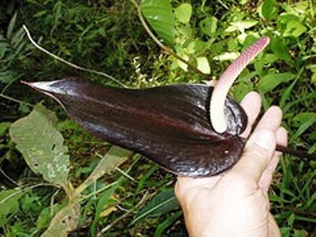
Jardín Botánico Anturio Negro |
| 6,7 Km |
 |
Balboa |
| 7,2 Km |
 |
Apía |
| 13,5 Km |
 |
Hotel reservation near The Celia within a radius of 20 km
Why to book with CLUBE TRAVEL
The best prices
Our partnerships with the world´s largest operators offer research on the best market prices.
More options
At Rotas Turisticos you can book the hotel, buy the air ticket, book the transfer from the airport to the hotel and vice versa, book the local excursions, rent the car, take travel insurance and consult the places to visit and where to go.
Holiday Tips & Destinations
Hundreds of holiday destinations with all the options that allow you to easily choose the destination that best suits your dream vacation.
CLUBE TRAVEL
Links
Follow us on social networks


